
Is the UNESCO World Heritage Sites Programme a cultural feature of globalisation?
The Wadden Sea - Netherlands, Germany and Denmark

Wadden Sea in Germany, Hallig Hooge and Pellworm
The Wadden Sea is an intertidal zone in the southeastern part of the North Sea. It lies between the coast of northwestern continental Europe and the range of low-lying Frisian Islands, forming a shallow body of water with tidal flats and wetlands. It is rich in biological diversity. In 2009, the Dutch and German parts of the Wadden Sea were inscribed on UNESCO's World Heritage List and the Danish part was added in June 2014.
Hanseatic City of Lübeck - Germany

Lübeck is a city in Schleswig-Holstein, northern Germany, and one of the major ports of Germany. On the river Trave, it was the leading city of the Hanseatic League, and because of its extensive Brick Gothic architecture, it is listed by UNESCO as a World Heritage Site.
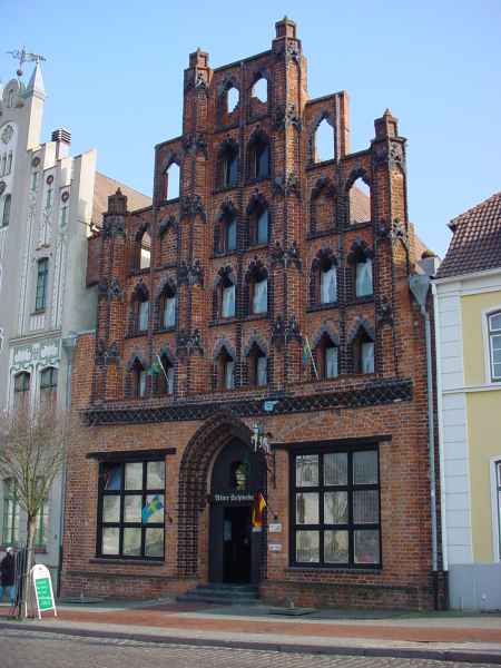
The skyline of the old town island of Stralsund - Germany

Stralsund seen from Altefähr. UNESCO awarded the old town island of Stralsund World Heritage status in 2002. It features many important historical buildings from different eras, going right back to Gothic architecture.
Stralsund is a Hanseatic town in the Pomeranian part of Mecklenburg-Vorpommern, Germany. It is located at the Southern coast of the Strelasund, a sound of the Baltic Sea separating the island of Rügen from the mainland.
The Strelasund Crossing with its two bridges and several ferry services connects Stralsund with Rügen. The Western Pomeranian town has been the capital of the Vorpommern-Rügen district since the 2011 district reforms. It is the fourth-largest city of Mecklenburg-Vorpommern and, together with Greifswald, Stralsund forms an Oberzentrum, one of four high-level urban centers of the region.
Stralsund was granted city rights in 1234 and was one of the most prospering members of the medieval Hanseatic League. In 1628, during the Thirty Years' War, Stralsund came under Swedish rule and remained so until the upheavals of the Napoleonic Wars. In the 19th century it became part of Prussia and Germany. Since 2002, Stralsund's old town with its rich heritage is honored as a UNESCO World Heritage, along with Wismar in Mecklenburg.
The Hanseatic Port of Wismar - Germany
Wismar is a port and Hanseatic city in Northern Germany on the Baltic Sea, in the state of Mecklenburg-Vorpommern. It is located about 45 kilometres (28 miles) east of Lübeck and 30 kilometres (19 miles) north of Schwerin, and is part of the Hamburg Metropolitan Region. Its natural harbour, located in the Bay of Wismar, is well-protected by a promontory. The population was 42,219 in 2013. It is the capital of the district of Nordwestmecklenburg.
With its origins as a Slavic settlement, Wismar's recorded history began in the 12th century. At various times, Wismar has been part of Mecklenburg, Sweden or Germany, including East Germany. It became part of Germany in 1871, though Sweden officially renounced its claims to the city in 1903. A unique representative of the Hanseatic League city type, with its Brick Gothic constructions and many patrician gable houses, Wismar has been included in the UNESCO list of World Heritage Sites since 2002, together with the historical core of Stralsund.
The medieval town of Toruń - Poland

Medieval Town of Toruń (Polish: zespół staromiejski Torunia) is the oldest historic district of the city of Toruń. It is one of World Heritage Sites in Poland (added in 1997). According to UNESCO, its value lies in its being "a small historic trading city that preserves to a remarkable extent its original street pattern and outstanding early buildings, and which provides an exceptionally complete picture of the medieval way of life". The Medieval Town has an area of 60 ha and a buffer zone of 300 ha. It is composed of the Toruń Old Town, Toruń New Town, and the Toruń Castle.[
Warsaw's Old Town - Poland

Warsaw's Old Town has been placed on the UNESCO's list of World Heritage Sites as "an outstanding example of a near-total reconstruction of a span of history covering the 13th to the 20th century. The site is also one of Poland's official national Historic Monuments (Pomnik historii), as designated September 16, 1994. Its listing is maintained by the National Heritage Board of Poland.
Zamość - Poland

The osiedle Old City (Polish: Osiedle Stare Miasto) is the oldest historic district of the city of Zamość. It is one of World Heritage Sites in Poland (added in 1992). According to UNESCO, this monument value lies in it being "an outstanding example of a Renaissance planned town of the late 16th century, which retains its original layout and fortifications and a large number of buildings of particular interest, blending Italian and Central European architectural traditions.". The Medieval Town has an area of 75 ha and a buffer zone of 200 ha. The district was named one of Poland's official national Historic Monuments (Pomnik historii), as designated September 16, 1994. Its listing is maintained by the National Heritage Board of Poland.
Kiev Pechersk Lavra, also known as the Kiev Monastery of the Caves - a historic Orthodox Christian monastery in Kiev, Ukraine

Kiev Pechersk Lavra or Kyiv Pechersk Lavra[3][4](Ukrainian: Києво-Печерська лавра: Kyievo-Pechers'ka lavra, Russian: Киeво-Печерская лавра: Kievo-Pecherskaya lavra), also known as the Kiev Monastery of the Caves, is a historic Orthodox Christian monastery which gave its name to one of the city districts where it is located in Kiev.
Since its foundation as the cave monastery in 1051[5] the Lavra has been a preeminent center of Eastern Orthodox Christianity in Eastern Europe. Together with the Saint Sophia Cathedral, it is inscribed as a UNESCO World Heritage Site.[6][nb 1] The monastery complex is considered a separate national historic-cultural preserve (sanctuary), the national status to which was granted on 13 March 1996.[8] The Lavra is not only located in another part of the city, but is part of a different national sanctuary than Saint Sophia Cathedral. While being a cultural attraction, the monastery is once again active, with over 100 monks in residence.[citation needed] It was named one of the Seven Wonders of Ukraine on 21 August 2007, based on voting by experts and the internet community.
Saint Sophia Cathedral - Kiev, Ukraine

Saint Sophia Cathedral in Kiev is an outstanding architectural monument of Kievan Rus'. The cathedral is one of the city's best known landmarks and the first heritage site in Ukraine to be inscribed on the World Heritage List along with the Kiev Cave Monastery complex. Aside from its main building, the cathedral includes an ensemble of supporting structures such as a bell tower and the House of Metropolitan. In 2011 the historic site was reassigned from the jurisdiction of the Ministry of Regional Development of Ukraine to the Ministry of Culture of Ukraine. One of the reasons for the move was that both Saint Sophia Cathedra and Kiev Pechersk Lavra are recognized by the UNESCO World Heritage Program as one complex, while in Ukraine the two were governed by different government entities.
In Ukrainian the cathedral is known as Sobor Sviatoyi Sofiyi (Собор Святої Софії) or Sofiyskyi sobor (Софійський собор). In Russian it is known as Sobor Svyatoi Sofii (Собор Святой Софии) or Sofiyskiy sobor (Софийский собор).
The complex of the cathedral is the main component and museum of the National Sanctuary "Sophia of Kiev" which is the state institution responsible for the preservation of the cathedral complex as well as four other historic landmarks across the nation.
Nisa (also Parthaunisa) - an ancient settlement of the Iranic peoples, southwest of Ashgabat, Turkmenistan

Nisa (also Parthaunisa) was an ancient settlement of the Iranic peoples, located near (modern-day) Bagir village, 18 km southwest of Ashgabat, Turkmenistan. Nisa is described by some as the first seat of central government of the Parthians. It is traditionally assumed to be founded by Arsaces I (reigned c. 250 BC–211 BC) and was reputedly the royal necropolis of the Parthian kings, although it has not been established that the fortress at Nisa was either a royal residence or a mausoleum. Nisa was a major trading hub in the Parthian Empire.
Excavations at Nisa have revealed substantial buildings, mausoleums and shrines, many inscribed documents and a looted treasury. Many Hellenistic art works have been uncovered as well as a large number of ivory rhytons, the outer rims (coins) decorated with Iranian subjects or classical mythological scenes.
The fortress at Nisa was declared a World Heritage Site by UNESCO in 2007.
Takht-i-Bahi - site of an ancient Buddhist monastery in Mardan, Khyber-Pakhtunkhwa, Pakistan

Takht-i-Bahi (Urdu: تختِ باہی; "Throne of the water spring") is an Indo-Parthian archaeological site of an ancient Buddhist monastery in Mardan, Khyber-Pakhtunkhwa, Pakistan. The site is considered the among the most imposing relics of Buddhism in all of Gandhara, and has been "exceptionally well-preserved."
The Buddhist monastery was founded in the 1st century CE, and was in use until the 7th century. The complex is regarded by archaeologists as being particularly representative of the architecture of Buddhist monastic centers from its era. Takht-i-Bahi was listed as a UNESCO World Heritage Site in 1980.
Seri Bahlol - located near Takht-i-Bahi, about 70 kilometer north-west of Peshawar, Khyber Pakhtunkhwa, Pakistan

Seri Bahlol, also Sahri Bahlol (Urdu: سری بہلول), is located near Takht-i-Bahi, about 70 kilometer north-west of Peshawar, Khyber Pakhtunkhwa, Pakistan.
Seri Bahlol is a place of historical significanceand it has been included in the UNESCO World Heritage List since 1980. The ruins of Seri Bahlol are the remnants of a small ancient fortified town built during the Kushan period.
It contains the remains of Buddha, which have not been properly excavated. Antiques such as statues, coins, utensils and jewellery are commonly found. The local people continue illegal excavation in their homes and land, damaging the historical monuments. Some of the local dealers of antiques encourage the local population to engage in illegal excavation. This requires urgent national and international attention in order to preserve this archaeology.
Taxila - an important archaeological site in Taxila city, Rawalpindi District of the Punjab, Pakistan

Taxila (from Pāli: Takkasilā, meaning "City of Cut Stone" or "Takṣa Rock") is an important archaeological site in Taxila city, Rawalpindi District of the Punjab, Pakistan, situated about 32 km (20 mi) north-west of Islamabad and Rawalpindi, just off the famous Grand Trunk Road. The city lies 549 metres (1,801 ft) above sea level. It is the headquarters of the Taxila Tehsil in the Rawalpindi district.
Ancient Taxila was situated at the pivotal junction of the Indian subcontinent and Central Asia. The origin of Taxila as a city goes back to c. 1000 BCE. Some ruins at Taxila date to the time of the Achaemenid Empire in the 6th century BCE, followed successively by Mauryan Empire, Indo-Greek, Indo-Scythian, and Kushan Empire periods.
Owing to its strategic location, Taxila has changed hands many times over the centuries, with many empires vying for its control. When the great ancient trade routes connecting these regions ceased to be important, the city sank into insignificance and was finally destroyed by the nomadic Hunas in the 5th century. The renowned archaeologist Sir Alexander Cunningham rediscovered the ruins of Taxila in the mid-19th century. In 1980, Taxila was declared a UNESCO World Heritage Site. In 2006 it was ranked as the top tourist destination in Pakistan by The Guardian newspaper.
Rohtas Fort - a 16th-century fortress near the city of Jhelum in the Pakistani province of Punjab

Rohtas Fort (Punjabi, Urdu: قلعہ روہتاس; Qila Rohtas) is a 16th-century fortress located near the city of Jhelum in the Pakistani province of Punjab.The fortress was built during the reign of the Pashtun king Sher Shah Suri between 1541 and 1548 in order to help subdue the rebellious tribes of the Potohar region of northern Punjab that were loyal to the Mughal crown. The fort is one of the largest and most formidable in the subcontinent. Rohtas Fort was never stormed by force, and has survived remarkably intact.
The fort is known for its large defensive walls, and several monumental gateways. Rohtas Fort was inscribed by UNESCO as a World Heritage Site in 1997 for being an "exceptional example of the Muslim military architecture of Central and South Asia."
The Lahore Fort - a citadel in the city of Lahore, Pakistan

The Lahore Fort (Shahi Qila, or "Royal Fort"), is a citadel in the city of Lahore, Pakistan. The fortress is located at the northern end of Lahore's Walled City, and spreads over an area greater than 20 hectares. It contains 21 notable monuments, some of which date to the era of Emperor Akbar. The Lahore Fort is notable for having been almost entirely rebuilt in the 17th century, when the Mughal Empire was at the height of its splendour and opulence.
Though the site of the Lahore Fort has been inhabited for millennia, the first record of a fortified structure at the site was in regard to an 11th-century mud-brick fort. The foundations of the modern Lahore Fort date to 1566 during the reign of Emperor Akbar, who bestowed the fort with a syncretic architectural style that featured both Islamic and Hindu motifs. Additions from the Shah Jahan period are characterized by luxurious marble with inlaid Persian floral designs, while the fort's grand and iconic Alamgiri Gate was constructed by the last of the great Mughal Emperors, Aurangzeb, and faces the renowned Badshahi Mosque.
After the fall of the Mughal Empire, the Lahore Fort was used as the residence of Ranjit Singh, founder of the Sikh Empire. The fort then passed to British colonialists after they annexed Punjab following their victory over the Sikhs at the Battle of Gujrat in February 1849. In 1981, the fort was inscribed as a UNESCO World Heritage Site for its "outstanding repertoire" of Mughal monuments dating from the era when the empire was at its artistic and aesthetic zenith.
The Shalimar Gardens - a Mughal garden complex in Lahore, capital of the province of Punjab, Pakistan

The Shalimar Gardens, sometimes spelt Shalamar Gardens, is a Mughal garden complex located in Lahore, capital of the Pakistani province of Punjab. The gardens date from the period when the Mughal Empire was at its artistic and aesthetic zenith, and are now one of Pakistan's most popular tourist destinations.
The Shalimar Gardens were laid out as a Persian paradise garden intended to create a representation of an earthly utopia in which humans co-exist in perfect harmony with all elements of nature.[2] Construction of the gardens began in 1641 during the reign of Emperor Shah Jahan,[2] and was completed in 1642.[3] In 1981 the Shalimar Gardens were inscribed as a UNESCO World Heritage Site as they embody Mughal garden design at the apogee of its development.
Fatehpur Sikri - a town in the Agra District of Uttar Pradesh, India

Fatehpur Sikri is a town in the Agra District of Uttar Pradesh, India. The city itself was founded as the capital of Mughal Empire in 1571 by Emperor Akbar (Originally built by Sikarwar Khanzada Rajputs ruler of Sikar Rajasthan), serving this role from 1571 to 1585, when Akbar abandoned it due to a campaign in Punjab and was later completely abandoned in 1610.
The name of the city derives from the village called Sikri which occupied the spot before. An Archaeological Survey of India (ASI) excavation from 1999-2000 indicated that there was a habitation, temples and commercial centres here before Akbar built his capital. It was also a much-loved place of Babur who called it Shukri for its lake of water needed for his armies. He used it for relaxation and also defeated Rana Sanga on its outskirts.
The khanqah of Sheikh Salim existed earlier at this place. Akbar's son Jahangir was born at the village of Sikri in 1569 and that year Akbar began construction of a religious compound to commemorate the Sheikh who had predicted the birth. After Jahangir's second birthday, he began the construction of a walled city and imperial palace here. The city came to be known as Fatehpur Sikri, the "City of Victory", after Akbar's victorious Gujarat campaign in 1573.
After occupying Agra in 1803, the English established an administrative center here and it remained so until 1850. In 1815, the Marquess of Hastings ordered repairment of monuments at Sikri.
Agra Fort - Uttar Pradesh, India

Agra Fort is a historical fort in the city of Agra in India. It was the main residence of the emperors of the Mughal Dynasty till 1638, when the capital was shifted from Agra to Delhi. The Agra fort is a UNESCO World Heritage site.[1] It is about 2.5 km northwest of its more famous sister monument, the Taj Mahal. The fort can be more accurately described as a walled city.
Taj Mahal - Uttar Pradesh, India

The Taj Mahal (meaning "Crown of the Palace") is an ivory-white marble mausoleum on the south bank of the Yamuna river in the Indian city of Agra. It was commissioned in 1632 by the Mughal emperor, Shah Jahan (reigned from 1628 to 1658), to house the tomb of his favourite wife, Mumtaz Mahal. The tomb is the centrepiece of a 17-hectare (42-acre) complex, which includes a mosque and a guest house, and is set in formal gardens bounded on three sides by a crenellated wall.
Construction of the mausoleum was essentially completed in 1643 but work continued on other phases of the project for another 10 years. The Taj Mahal complex is believed to have been completed in its entirety in 1653 at a cost estimated at the time to be around 32 million rupees, which in 2015 would be approximately 52.8 billion rupees (U.S. $827 million). The construction project employed some 20,000 artisans under the guidance of a board of architects led by the court architect to the emperor, Ustad Ahmad Lahauri.
The Taj Mahal was designated as a UNESCO World Heritage Site in 1983 for being "the jewel of Muslim art in India and one of the universally admired masterpieces of the world's heritage". It is regarded by many as the best example of Mughal architecture and a symbol of India's rich history. The Taj Mahal attracts 7–8 million visitors a year. In 2007, it was declared a winner of the New7Wonders of the World (2000–2007) initiative.
Sanchi Stupa - a Buddhist complex at Sanchi, Raisen District, Madhya Pradesh, India

Sanchi Stupa, also written Sanci, is a Buddhist complex, famous for its Great Stupa, on a hilltop at Sanchi Town in Raisen District of the State of Madhya Pradesh, India. It is located in 46 kilometres (29 mi) north-east of Bhopal, capital of Madhya Pradesh. The Great Stupa at Sanchi is one of the oldest stone structures in India, and an important monument of Indian Architecture.
It was originally commissioned by the emperor Ashoka in the 3rd century BCE. Its nucleus was a simple hemispherical brick structure built over the relics of the Buddha. It was crowned by the chatra, a parasol-like structure symbolising high rank, which was intended to honour and shelter the relics.
The original construction work of this stupa was overseen by Ashoka, whose wife Devi was the daughter of a merchant of nearby Vidisha. Sanchi was also her birthplace as well as the venue of her and Ashoka's wedding. In the 1st century BCE, four elaborately carved toranas (ornamental gateways) and a balustrade encircling the entire structure were added.
It became a UNESCO World Heritage Site on January 24, 1989 for its unique cultural importance.
The Khajuraho Group of Monuments is a group of Hindu, Buddhist and Jain temples - Madhya Pradesh, India

The Khajuraho Group of Monuments is a group of Hindu, Buddhist and Jain temples in Madhya Pradesh, India, about 175 kilometres (109 mi) southeast of Jhansi. They are one of the UNESCO World Heritage Sites in India. The temples are famous for their nagara-style architectural symbolism and their erotic sculptures.
Most Khajuraho temples were built between 950 and 1050 by the Chandela Rajput dynasty. Historical records note that the Khajuraho temple site had 85 temples by the 12th century, spread over 20 square kilometers Of these, only about 25 temples have survived, spread over 6 square kilometers. Of the various surviving temples, the Kandariya Mahadeva Temple is decorated with a profusion of sculptures with intricate details, symbolism and expressiveness of ancient Indian art.
The Khajuraho group of temples were built together but were dedicated to two religions, Hinduism and Jainism, suggesting a tradition of acceptance and respect for diverse religious views among Hindus and Jains in the region.
Konark Sun Temple - Odisha, India

Konark Sun Temple is a 13th-century CE sun temple at Konark about 35 kilometres (22 mi) northeast from Puri on the coastline of Odisha, India. The temple is attributed to king Narasimhadeva I of the Eastern Ganga Dynasty about 1250 CE.
Dedicated to the Hindu god Surya, what remains of the temple complex has the appearance of a 100-foot (30 m) high chariot with immense wheels and horses, all carved from stone. Once over 200 feet (61 m) high, much of the temple is now in ruins, in particular the large shikara tower over the sanctuary; at one time this rose much higher than the mandapa that remains. The structures and elements that have survived are famed for their intricate artwork, iconography, and themes, including erotic kama and mithuna scenes. Also called the Surya Devalaya, it is a classic illustration of the Odisha style of Hindu temple architecture.
The cause of the destruction of the Konark temple is unclear and remains a source of controversy. Theories range from natural damage to deliberate destruction of the temple in the course of being sacked several times by Muslim armies between the 15th and 17th centuries. This temple was called the "Black Pagoda" in European sailor accounts as early as 1676 because its great tower appeared black. Similarly, the Jagannath Temple in Puri was called the "White Pagoda". Both temples served as important landmarks for sailors in the Bay of Bengal. The temple that exists today was partially restored by the conservation efforts of British India-era archaeological teams. Declared a UNESCO world heritage site in 1984, it remains a major pilgrimage site for Hindus, who gather here every year for the Chandrabhaga Mela around the month of February.
Kota Tua Jakarta ("Jakarta Old Town") - Java. Indonesia

A potential location on the UNESCO World Heritage Sites tentative list for Indonesia is Kota Tua Jakarta ("Jakarta Old Town"), officially known as Kota Tua, is a neighborhood comprising the original downtown area of Jakarta, Indonesia. It is also known as Oud Batavia (Dutch "Old Batavia"), Benedenstad (Dutch "Lower City", contrasting it with Weltevreden, de Bovenstad ("Upper City")), or Kota Lama (Indonesian "Old Town").
The site contains Dutch-style structures mostly dated from 17th century, when the port city served as the Asian headquarter of VOC during the heyday of spice trade. It spans 1.3 square kilometres within North Jakarta and West Jakarta (Kelurahan Pinangsia, Taman Sari and Kelurahan Roa Malaka, Tambora). The largely Chinese downtown area of Glodok is a part of Kota Tua.
Borobudur - Java, Indonesia

Borobudur, or Barabudur (Indonesian: Candi Borobudur, Javanese: ꦕꦤ꧀ꦣꦶꦧꦫꦧꦸꦣꦸꦂ, translit. Candhi Barabudhur) is a 9th-century Mahayana Buddhist temple in Magelang Regency, not far from the town of Muntilan, in Central Java, Indonesia. It is one of the world's largest Buddhist temples. The temple consists of nine stacked platforms, six square and three circular, topped by a central dome. It is decorated with 2,672 relief panels and 504 Buddha statues. The central dome is surrounded by 72 Buddha statues, each seated inside a perforated stupa.
Built in the 9th century during the reign of the Sailendra Dynasty, the temple design follows Javanese Buddhist architecture, which blends the Indonesian indigenous cult of ancestor worship and the Buddhist concept of attaining Nirvana. The temple demonstrates the influences of Gupta art that reflects India's influence on the region, yet there are enough indigenous scenes and elements incorporated to make Borobudur uniquely Indonesian. The monument is a shrine to the Lord Buddha and a place for Buddhist pilgrimage. The pilgrim journey begins at the base of the monument and follows a path around the monument, ascending to the top through three levels symbolic of Buddhist cosmology: Kāmadhātu (the world of desire), Rupadhatu (the world of forms) and Arupadhatu (the world of formlessness). The monument guides pilgrims through an extensive system of stairways and corridors with 1,460 narrative relief panels on the walls and the balustrades. Borobudur has one of the largest and most complete ensembles of Buddhist reliefs in the world.
Evidence suggests Borobudur was constructed in the 9th century and abandoned following the 14th-century decline of Hindu kingdoms in Java and the Javanese conversion to Islam. Worldwide knowledge of its existence was sparked in 1814 by Sir Thomas Stamford Raffles, then the British ruler of Java, who was advised of its location by native Indonesians. Borobudur has since been preserved through several restorations. The largest restoration project was undertaken between 1975 and 1982 by the Indonesian government and UNESCO, followed by the monument's listing as a UNESCO World Heritage Site.
Prambanan - Java, Indonesia

Prambanan or Rara Jonggrang (Javanese: ꦫꦫꦗꦺꦴꦁꦒꦿꦁ) is a 9th-century Hindu temple compound in Central Java, Indonesia, dedicated to the Trimurti, the expression of God as the Creator (Brahma), the Preserver (Vishnu) and the Transformer (Shiva). The temple compound is located approximately 17 kilometres (11 mi) northeast of the city of Yogyakarta on the boundary between Central Java and Yogyakarta provinces.
The temple compound, a UNESCO World Heritage Site, is the largest Hindu temple site in Indonesia, and one of the biggest in Southeast Asia. It is characterized by its tall and pointed architecture, typical of Hindu architecture, and by the towering 47-metre-high (154 ft) central building inside a large complex of individual temples. Prambanan attracts many visitors from around the world.
The Purnululu National Park - Western Australia, Australia

The Purnululu National Park is a World Heritage Site in the East Kimberley region of Western Australia. The 239,723-hectare (592,370-acre) national park is located approximately 300 kilometres (190 mi) south of Kununurra, with Halls Creek located to the south. Declared a World Heritage Site in 2003, the park was inscribed as follows:
...[is a] remote area managed as wilderness. It includes the Bungle Bungle Range, a spectacularly incised landscape of sculptured rocks which contains superlative examples of beehive-shaped karst sandstone rising 250 metres above the surrounding semi-arid savannah grasslands. Unique depositional processes and weathering have given these towers their spectacular black and orange banded appearance, formed by biological processes of cyanobacteria (single cell photosynthetic organisms) which serve to stabilise and protect the ancient sandstone formations. These outstanding examples of cone karst that have eroded over a period of 20 million years are of great beauty and exceptional geological interest.
The Royal Exhibition Building and the Carlton Gardens - Victoria, Australia

The Royal Exhibition Building is a World Heritage Site-listed building in Melbourne, Australia, completed in 1880. It is located at 9 Nicholson Street in the Carlton Gardens, flanked by Victoria, Carlton and Rathdowne Streets, at the north-eastern edge of the central business district. It was built to host the Melbourne International Exhibition in 1880–81 and later hosted (in the Western annex) the opening of the first Parliament of Australia in 1901. Throughout the 20th century smaller sections and wings of the building were subject to demolition and fire; however, the main building, known as the Great Hall, survived.
It received restoration throughout the 1990s and in 2004 became the first building in Australia to be awarded UNESCO World Heritage status, being one of the last remaining major 19th-century exhibition buildings in the world. It is the world's most complete surviving site from the International Exhibition movement 1851–1914. It sits adjacent to the Melbourne Museum and is the largest item in Museum Victoria's collection. Today, the building hosts various exhibitions and other events and is closely tied with events at the Melbourne Museum.
Te Wāhipounamu - South Island, New Zealand

Te Wāhipounamu (Māori for "the place of greenstone") is a World Heritage Site in the south west corner of the South Island of New Zealand.
Inscribed on the World Heritage List in 1990 and covering 26,000 km², the site incorporates four national parks:

Aoraki/Mount Cook National Park is in the South Island of New Zealand, near the town of Twizel. Aoraki / Mount Cook, New Zealand's highest mountain, and Aoraki/Mount Cook Village lie within the park. The area was gazetted as a national park in October 1953 and consists of reserves that were established as early as 1887 to protect the area's significant vegetation and landscape.

Fiordland National Park occupies the southwest corner of the South Island of New Zealand. It is the largest of the 14 national parks in New Zealand, with an area of 12,607 square kilometres (4,868 sq mi), and a major part of the Te Wahipounamu World Heritage site. The park is administered by the Department of Conservation.

Mount Aspiring National Park is in the Southern Alps of the South Island of New Zealand, north of Fiordland National Park, and between Otago and south Westland. The park forms part of the Te Wahipounamu World Heritage site. In 2009 the National-led government of New Zealand indicated that Mount Aspiring National Park may be opened up to mining. Around 20% of the total area of the park, mainly in the western portions around the Red Hill Range, and the north eastern parts, could be removed from the park and mined. The Green Party has warned that the park is one of New Zealand's main tourism drawcards, and that mining here could do significant damage to the country's image.

Westland Tai Poutini National Park is located on the western coast of New Zealand's South Island. Established in 1960, the centenary of the European settlement of Westland District, it covers 1,320 km², and extends from the highest peaks of the Southern Alps to a wild and remote coastline.[1][2] It borders the Aoraki/Mount Cook National Park along the Main Divide.
Included in the Te Wāhipounamu park are glaciers, scenic lakes, and dense temperate rainforest, as well as remains of old gold mining towns along the coast. Franz Josef Glacier and Fox Glacier are two popular tourist attractions within Westland Tai Poutini National Park.
It is thought to contain some of the best modern representations of the original flora and fauna of Gondwana, one of the reasons for its listing as a World Heritage site. Te Wahipounamu was added to the UNESCO World Heritage List in 1990. The Westland and Mount Cook National Park and the Fiordland National Park were previously inscribed on the list, but are now considered under Te Wahipounamu, which covers all of these areas. To be inscribed on this list, Te Wahipounamu met several criteria. It contains many of the natural features that contribute to New Zealand’s reputation as a place with exceptional landscapes. It is considered the best modern example of the biota of Gondwanaland and is therefore of global significance. There is a high degree of geodiversity and biodiversity and the habitats are largely unmodified. And finally, there is an extensive range of New Zealand’s unusual flora and fauna, which demonstrate its evolutionary isolation.
Paisaje Cultural Cafetero - The Coffee Cultural Landscape - Colombia

The Colombian Coffee Cultural Landscape, Paisaje Cultural Cafetero (PCC) is an outstanding example of human adaptation to difficult geographical conditions that includes the development of coffee cultivation on steep hill and mountainsides. This is a cultural landscape where natural, economic and cultural elements combine to create an exceptional case of a creative and social interaction that is sustainable with the natural environment. This is a unique example in the whole world, where in this landscape, human activity, shaped by family and generational efforts of theses coffee growers is combined with the sustainability of these social and political institutions.
Together, these cultural activities have established an exceptional model of collective action that has allowed the communities in this landscape to overcome difficult economic circumstances and survive in a wild and isolated landscape. In this way, coffee plantations based on small properties have developed, demonstrating a significant degree of sustainability in economic, social and environmental terms, and which has positioned the end product as one of the best coffees in the world. This social and economic model has shaped this region with a set of unique characteristics that form a cultural unity. This is expressed in a material cultural heritage that highlights the positive in both urban settlements and in the rural coffee houses. As well as this intangible cultural heritage the expression of this culture through carnivals and celebrations of the Paisa identity that is inherited from the Antioquia colonization, forms a unique cultural landscape created by the inhabitants of this region.
The World Heritage Committee of the United Nations Organization for Education, Science and Culture - UNESCO inscribed the Coffee Cultural Landscape on the World Heritage List on June 25, 2011. This recognition commits the Colombian State, the international, national and local community to its protection, but is at the same time an opportunity for its inhabitants and visitors to discover this landscape and participate in its preservation.
Cartagena - Colombia

The city of Cartagena, known in the colonial era as Cartagena de Indias, is a major port founded in 1533, located on the northern coast of Colombia in the Caribbean Coast Region. It was strategically located between the Magdalena and Sinú rivers and became the main port for trade between Spain and its overseas empire, establishing its importance by the early 1540s. During the colonial era it was a key port for the export of Peruvian silver to Spain and for the import of African slaves under the asiento system. It was defensible against pirate attacks in the Caribbean. It is the capital of the Bolívar Department, and had a population 971,592 as of 2016. It is the fifth-largest city in Colombia and the second largest in the region, after Barranquilla. The urban area of Cartagena is also the fifth-largest urban area in the country. Economic activities include the maritime and petrochemicals industries, as well as tourism.
The city was founded on June 1, 1533, and named after Cartagena, Spain, which in turn was named after Carthage in Tunisia. Settlement in the region around Cartagena Bay by various indigenous people dates back to 4000 BC. During the Spanish colonial period Cartagena served a key role in administration and expansion of the Spanish empire. It was a center of political, ecclesiastical, and economic activity. In 1984, Cartagena's colonial walled city and fortress were designated a UNESCO World Heritage Site.
Skellig Michael

Skellig Michael or the Great Skellig, is a twin-pinnacled crag situated 11.6 kilometres (7.2 mi) west of the Iveragh Peninsula in County Kerry, Ireland. Its twin island, "Little Skellig" is larger but practically inaccessible, and is closed to the public. The Skellig Islands, along with some of the Blasket Islands, form the most westerly part of the Republic of Ireland.
Skellig Michael consists of approximately 44 acres of rock, with its highest point, the Spit, 714 feet above sea level. It is known for its steep inhospitable landscape, the Gaelic monastery founded between the 6th and 8th century, and its variety of inhabiting species, including gannets, puffins, a colony of razorbills and a resident population of approximately fifty grey seals. The rock contains the remains of a tower house, a megalithic stone row and a cross inscribed slab known as the "Wailing Woman". The monastery is situated at 550–600 feet, while "Christ's Saddle" is 422 feet and the flagstaff area is 120 feet above sea level. The island's slopes are ascended by a flight of stone steps. The remains of the monastery, which today consists of a small enclosure of beehive huts and oratories, and most of the island, became a UNESCO World Heritage Site in 1996. Because of the often difficult crossing from the mainland and the exposed nature of the small landing spot, the island is only accessible to the public during the summer months.
The name "Skellig" is derived from a Gaelic word for a splinter of stone (sceilig). Skellig Michael is named after (dedicated) to the archangel Michael, said to have appeared there to help Saint Patrick banish serpents into the Irish sea.
The Rock of Cashel

A possible UNESCO World Heritage Site close to the LODE Zone is The Rock of Cashel. Also known as Cashel of the Kings and St. Patrick's Rock, this is a historic site located at Cashel, County Tipperary, Ireland. According to local mythology, the Rock of Cashel originated in the Devil's Bit, a mountain 20 miles (30 km) north of Cashel when St. Patrick banished Satan from a cave, resulting in the Rock's landing in Cashel. Cashel is reputed to be the site of the conversion of the King of Munster by St. Patrick in the 5th century.
The Rock of Cashel was the traditional seat of the kings of Munster for several hundred years prior to the Norman invasion. In 1101, the King of Munster, Muirchertach Ua Briain, donated his fortress on the Rock to the Church. The picturesque complex has a character of its own and is one of the most remarkable collections of Celtic art and medieval architecture to be found anywhere in Europe. Few remnants of the early structures survive; the majority of buildings on the current site date from the 12th and 13th centuries.
According to local mythology, the Rock of Cashel originated in the Devil's Bit, a mountain 20 miles (30 km) north of Cashel when St. Patrick banished Satan from a cave, resulting in the Rock's landing in Cashel. Cashel is reputed to be the site of the conversion of the King of Munster by St. Patrick in the 5th century.
Liverpool Maritime Mercantile City - England

The Liverpool Maritime Mercantile City is a UNESCO designated World Heritage Site in Liverpool, England. It comprises six locations in the city centre of Liverpool including the Pier Head, Albert Dock and William Brown Street, and includes many of the city's most famous landmarks. In July 2017, UNESCO warned that the city's status as a World Heritage Site was at risk of being rescinded in light of planning and development proposals, with English Heritage asserting that the proposed Liverpool Waters development would leave the setting of some of Liverpool’s most significant historic buildings “severely compromised”, the archaeological remains of parts of the historic docks “at risk of destruction”, and “the city’s historic urban landscape ... permanently unbalanced”.
No comments:
Post a Comment